It’s that time of year. Let’s talk winter forecast projections for the 2024-2025 winter season. Below is a full video breaking down the forecast.
Last winter was warm across much of North America with a widespread region from the Midwest into eastern Canada of extreme mild weather.
September 25, 2024 | Brian Ivey – Guest Editor/Meteorologist
Last winter was warm across much of North America with a widespread region from the Midwest into eastern Canada of extreme mild weather.
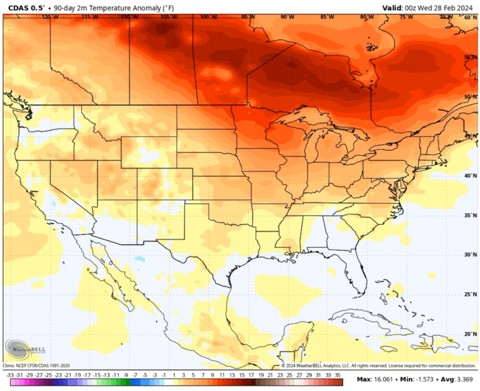
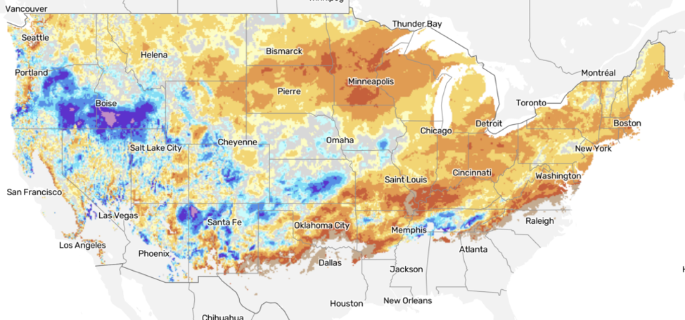
The snow side of things was also well below average overall. The darker the oranges and browns the less snow. Idaho into Oregon was the snowy sweet spot.
As we head into the 2024-2025 winter season, the atmospheric phenomenon known as La Niña will play a pivotal role in shaping the weather across the United States. We can expect a weak La Niña to influence this year’s winter, resulting in a wide variety of conditions across the country. So, what does this mean for you?
What is a Weak La Niña? La Niña is the cooler counterpart to El Niño, marked by cooler-than-average sea surface temperatures in the Pacific Ocean.
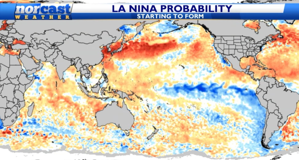
This cooling affects weather patterns across the globe, especially in North America. During a weak La Niña, the effects can be somewhat muted but still impactful. Typically, La Niña winters bring cooler and wetter conditions to the northern U.S. and warmer, drier conditions to the southern U.S. This year, the weaker version of the pattern means these effects may be less extreme but still noticeable.
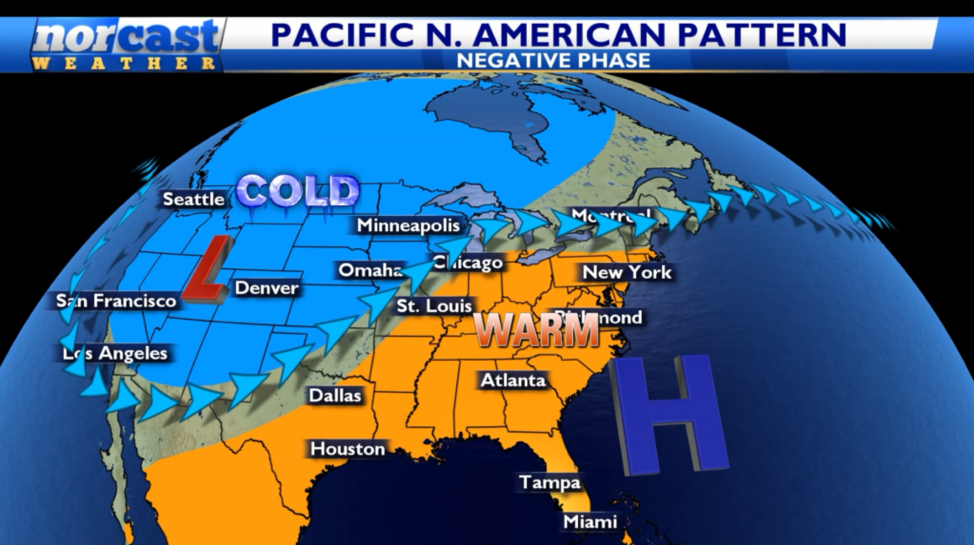
This can line up with a positive NAO and negative PNA pattern and create a further pronounced divider between the warm and cold air with different blocking pattern setups and a ridge near the Southeast US. This coupled with the fact of many of the recent winters have been pretty mild in the East and Central portion of America leads us to not see signs of any widespread long lasting cold and snowy regimes.
Regional Expectations
Northwest: this winter will likely bring above-average snowfall and colder-than-usual temperatures. Wetter conditions are expected to dominate from December through February. Ski resorts, snow contractors and outdoor enthusiasts in these regions might see a busy season with frequent snowfall.
Northeast: It’s probably another mild winter with less snow.
Great Lakes: There could be enough arctic intrusions to allow for closer to typical snow and cold, especially further west. The further south and east you go the better chances for more rain versus snow and enough mild air periods to be warm overall. This will be a battle zone area.
Rockies: Should be a good season for snowfall as you venture north. Might be drier closer to Denver.
Timing: When Will Winter Hit Hard?
Historically, weak La Niña patterns tend to produce the most significant winter weather in the early winter months of December into January. If you want widespread cold shots then early in the season could provide areas further south and east with the polar plunge. November and March could be pretty warm.
Best Snow Zone
Based on where the active jet stream pushes moisture into the nation and the best chance for Arctic air to hang out the Northwest should be the snow sweet spot. It will be below average from the middle of the nation into the South and East.
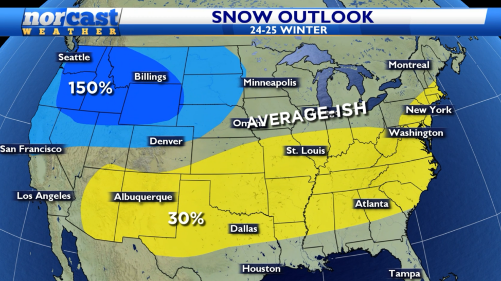
Even though many areas are marked as average from the Midwest into the Northeast that’s because there could be enough colder air intrusions with an active pattern. The winter as a whole might not be very snowy and cold, but there could be enough chances for bigger storms (setup favors temperature difference that helps lows form) that it might not take many events to get decent amounts.
For more info on Norcast Weather visit their website.
Want more information on this?
