La Niña returns for the third consecutive winter. What does that mean and how will it affect the winter?
November 9, 2022 | Emma Tyborski
The National Oceanic and Atmospheric Administration (NOAA) believes there is a 75 percent chance that La Niña will stick around through the winter, which will play a significant role in who will see snow.
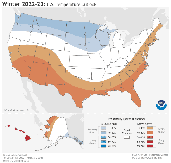
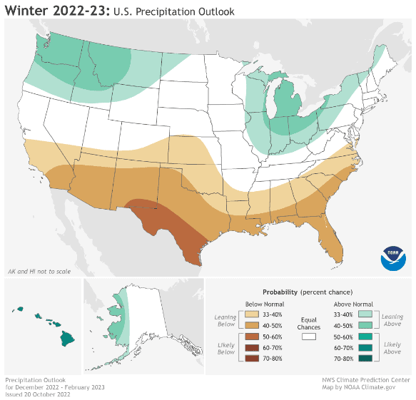
This year La Niña returns for the third consecutive winter, which is rare and challenging to predict the weather pattern because there have only been a few on record. According to NOAA’s U.S. Winter Outlook, this year’s La Niña winter will be driving warmer-than-average temperatures for the Southwest and along the Gulf Coast and eastern seaboard. Starting in December 2022 through February 2023, NOAA predicts drier-than-average conditions across the South with wetter-than-average conditions for areas of the Ohio Valley, Great Lakes, northern Rockies and Pacific Northwest.
So what is La Niña and why is it important? La Niña is a complex weather pattern resulting from fluctuations in ocean water temperatures. Natural influences such as pressure changes, excessive rainfall and temperature swings can play a significant role in changing the state of the Ocean and when extremes are reached the world can be in either a La Niña or El Niño.
El Niño is known as the warm phase and can bring extreme weather like floods, severe weather and blizzards. Warming Pacific Ocean surface waters cause the tension in the atmosphere that results in warmer than average temperatures over much of North America during winter months. Southern states can expect to be a bit cooler and wetter than normal. The warmer Eastern Pacific waters change global weather dynamics and fosters the odd weather. The effects are strongest during northern hemisphere winters because ocean temperatures globally are at their warmest.
La Niña on the other hand is known as the cool phase and typically the weather is not as extreme as El Niño. During a La Niña winter, temperatures tend to be warmer in the Southeast and cooler in the Northwest. Southern states will tend to see less precipitation.
The forecasters at NOAA’s Climate Prediction Center produce timely and accurate seasonal outlooks and short-term forecasts year-round and have provided the below temperature, precipitation and drought outlooks.

Temperature
- The greatest chance for warmer-than-average conditions are in western Alaska, and the Central Great Basin and Southwest extending through the Southern Plains.
- Warmer-than-average temperatures are also favored in the Southeastern U.S. and along the Atlantic coast.
- Below-normal temperatures are favored from the Pacific Northwest eastward to the western Great Lakes and the Alaska Panhandle.

Precipitation
- Wetter-than-average conditions are most likely in western Alaska, the Pacific Northwest, northern Rockies, Great Lakes and Ohio Valley.
- The greatest chances for drier-than-average conditions are forecast in portions of California, the Southwest, the southern Rockies, southern Plains, Gulf Coast and much of the Southeast.
- The remainder of the U.S. falls into the category of equal chances for below-, near-, or above-average seasonal total precipitation.

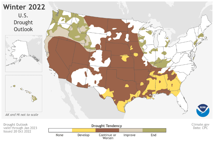
Drought
- Widespread extreme drought continues to persist across much of the West, the Great Basin, and the central-to-southern Great Plains.
- Drought is expected to impact the middle and lower Mississippi Valley this winter.
- Drought development is expected to occur across the South-central and Southeastern U.S., while drought conditions are expected to improve across the Northwestern U.S. over the coming months.
