Brian Ivey of Norcast Weather gives Snow Plow News an exclusive early look at what Winter 2025-2026 could hold backed by atmospheric signals, climatology, and trends that matter.
Let’s dive into an early look at what Winter 2025-2026 could hold backed by atmospheric signals, climatology, and trends that matter.
We’re still early in the game — September is too soon for high-confidence specifics — but the signals are forming, and they’re worth watching. We’re looking at analog years, ocean temperatures, jet stream behavior, and shifting climatological baselines that give us our first clues. Here’s what the science says so far.
Ocean Trends & Jet Stream Clues
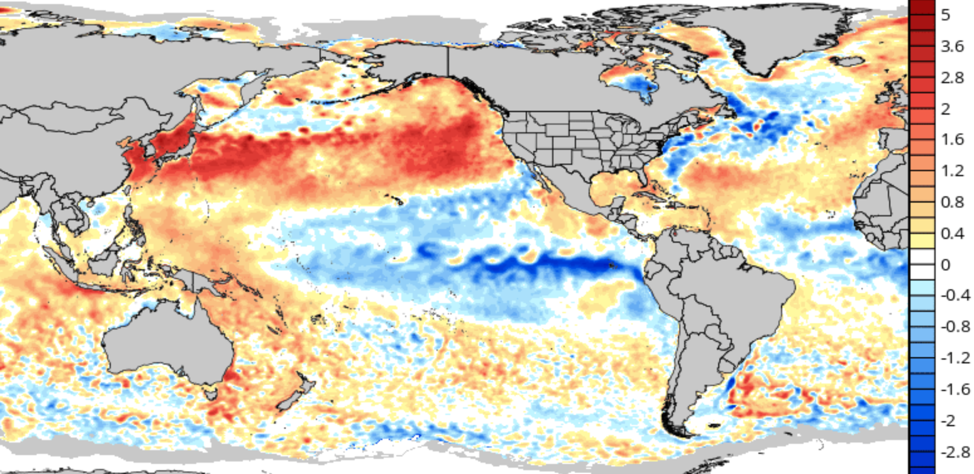
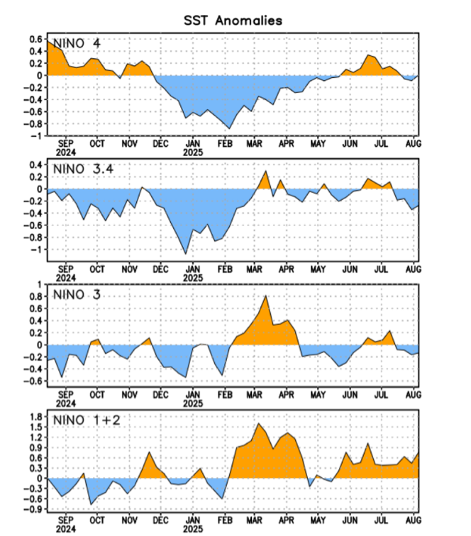
The most dominant player in seasonal forecasting is the El Niño–Southern Oscillation (ENSO). After a El Niño last year, we’re seeing a neutral phase emerging this fall, with some modeling leaning toward weak La Niña development by winter. Right now we are seeing a big push towards a colder equatorial Pacific Ocean.
Why does this matter? Neutral or weak La Niña conditions tend to disrupt predictability — but they also open the door to higher variability. Cold shots from Canada can dive deeper, storm tracks can swing harder, and regional differences become more pronounced. This is the kind of setup where we can see big winners and losers in snowfall — often only a state or two apart.
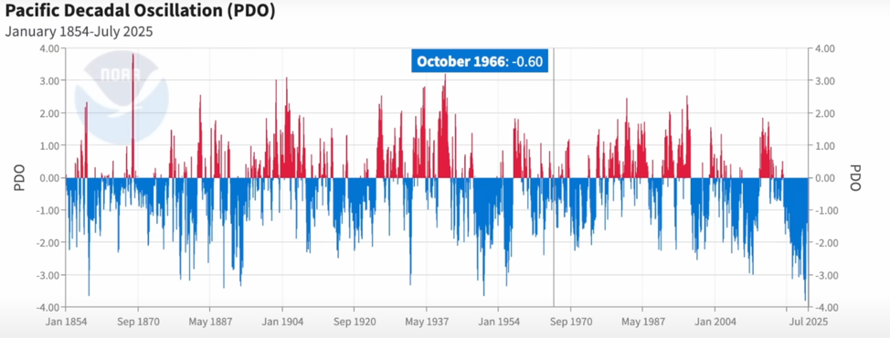
Meanwhile, the Pacific and Atlantic remain abnormally warm, especially in the north. That warmth influences blocking patterns and ridging, which can force the jet stream to buckle — often leading to cold intrusions and active storm tracks into the Midwest and Ohio Valley. Very cold waters off the shore of the West Coast are influenced by a record negative Pacific Decadal Oscillation. A very warm northern Pacific Ocean in many spots, but very far from it close to North America.
Solar Activity & Stratospheric Hints
We’re heading into the peak of Solar Cycle 25, which could subtly influence upper atmospheric conditions. Higher solar activity can dampen sudden stratospheric warming events (SSWs), which are typically a trigger for prolonged cold outbreaks in the eastern U.S.
That said, solar cycles don’t work in isolation — but they do influence polar vortex behavior, which is always worth monitoring mid to late winter.
Quick Recap On This Past Year
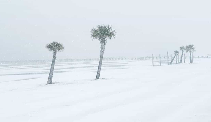
The pattern last winter featured a tug-of-war between brief arctic intrusions and long stretches of milder Pacific air, ultimately landing the season in the “warmer and drier” bucket for much of the U.S., but with sharp regional differences. The most notable event was the Gulf Coast heavy snowstorm.
This summer brought persistent humidity and stubbornly warm overnight lows, particularly across the eastern half of the country. While extreme heat wasn’t the standout story, the combination of high dew points and limited nighttime relief extended heat stress and created tough working conditions — especially in urban corridors and construction zones.
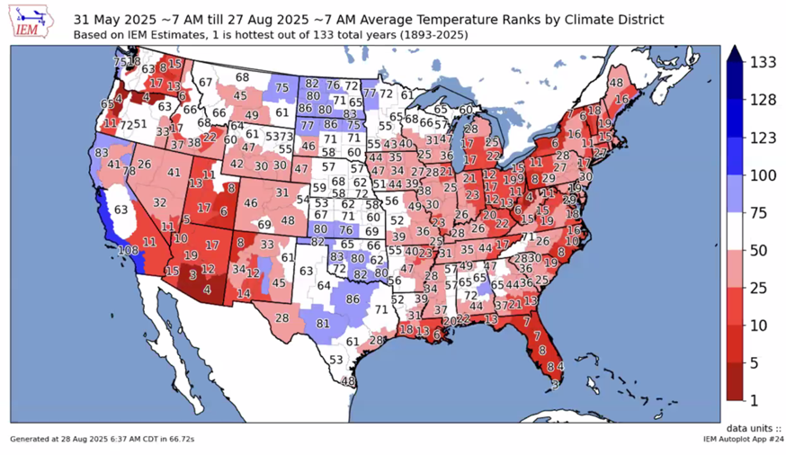
Two brief breaks in the heat — one in early June and another in late August — helped moderate the season slightly. Lake temps are warm and elevated temperatures could play a role with warmer ground temps into winter.
Seasonal Analogs: Looking Back to Look Ahead
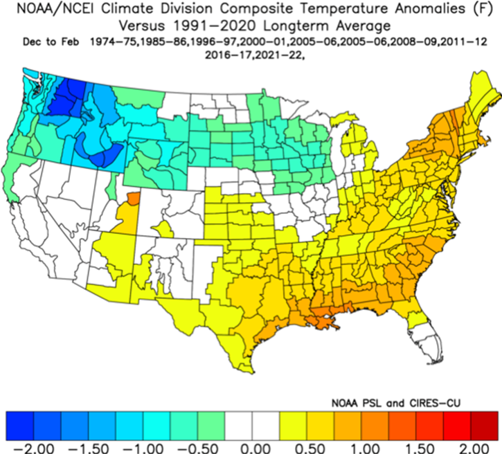
We’ve been studying analog years like 1978–79, 2008–09, and even 2010–11. These were seasons with ENSO-neutral to weak La Niña signatures, warm oceans, and some level of high-latitude blocking.
Each of those years brought notable snow seasons — particularly for the Great Lakes, Northeast, and Mid-Atlantic. But they were also volatile: stretches of warmth followed by sudden flips to cold and snow. That’s the kind of winter pattern we might be heading toward again.
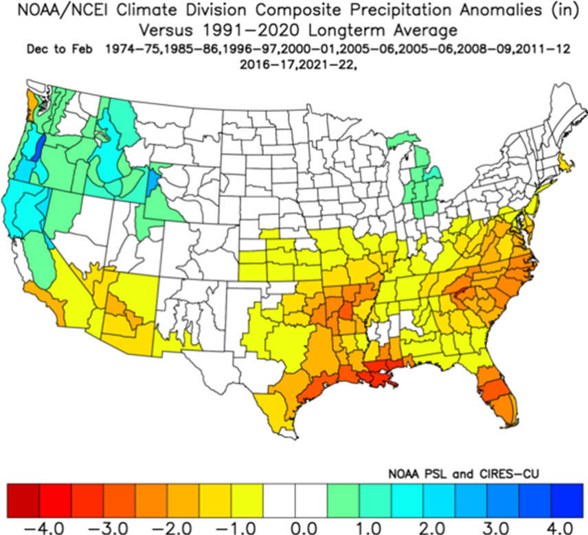
Climate Trends: Precipitation Is Changing
One longer-term trend that can’t be ignored: the amount of winter precipitation falling as snow is decreasing in many regions — especially across the southern U.S., lower Midwest, and Southeast.
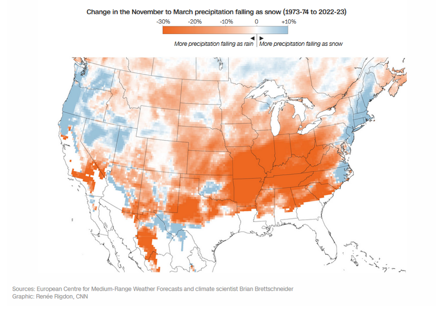
This isn’t about less precipitation — it’s about more of it falling as rain due to warming surface temperatures. That changes how snow contractors and municipalities need to prepare. More marginal events, fewer “slam dunk” snowstorms, and greater need for hyper-local weather decision support.
In typical weak La Niña or neutral years:
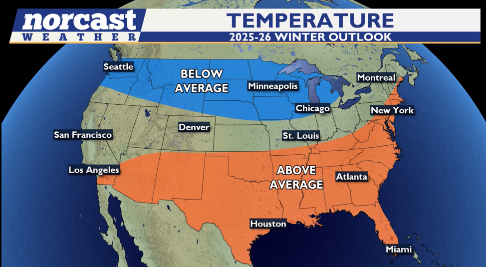
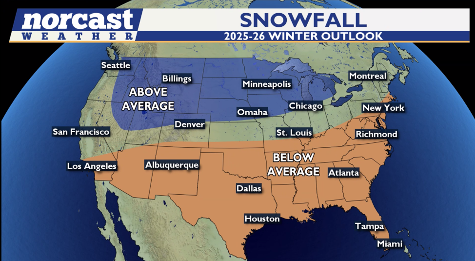
- Northern tier states (Upper Midwest, Great Lakes, Northern Plains, and interior Northeast) tend to experience colder and snowier conditions, especially post-January.
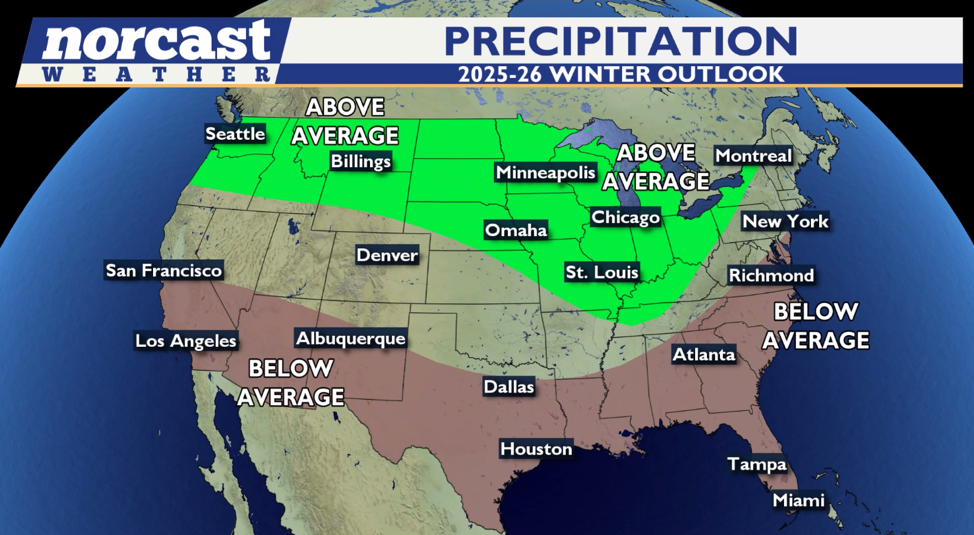
- Southern states may run drier, although occasional Gulf moisture events can still spark impactful storms.
- The West often sees increased storm activity from the Pacific Northwest into the northern Rockies.
Our forecast ideas echo this when combining different parameters and weighting things.
Early Regional Hints
Here’s where we stand based on pattern modeling, analogs, and current observations:
- Upper Midwest & Great Lakes: High potential for above-average snowfall. Cold outbreaks should be frequent enough to support persistent snowpack.
- Ohio Valley & Interior Northeast: Looking active, but outcomes will hinge on how frequently cold air overlaps with storm tracks.
- Mid-Atlantic & Coastal Northeast: Toss-up zone. One degree of temperature may mean snow or rain. Blocking in Greenland or North Atlantic will be key.
- Southern Plains & Southeast: Less favorable for snow. Expect continued trend of more rain than snow with limited Arctic intrusions.
- Rockies & Interior West: Could benefit from a strong western ridge pattern, but snowfall depends on storm placement.
Additional Angles to Watch
- Arctic Oscillation (AO) & North Atlantic Oscillation (NAO):
These indices often become more influential mid to late winter. A negative AO/NAO phase can enhance blocking and cold air delivery into the eastern U.S. — especially relevant for Ohio Valley and Northeast snow potential. - Siberian Snow Cover in October:
There’s some research suggesting that rapid snow cover expansion in Siberia during October correlates with increased likelihood of stratospheric disruptions and colder winters in the eastern U.S. Worth monitoring as a wildcard signal. - MJO (Madden-Julian Oscillation):
While more short-term, MJO phases can modulate tropical forcing and influence jet stream patterns. If we see active MJO phases in the western Pacific, that could enhance storminess across the U.S. — especially during transitional months like December and March.
What About Snowfall?
The Bottom Line (So Far)
We’re heading into a volatile but opportunity-rich winter, particularly for markets in the Midwest and interior Northeast. Don’t expect a mild, quiet season — but don’t expect it to behave like last year, either.
This season’s variability is the headline, with strong week-to-week swings likely. That means the contractors and agencies who stay plugged in — to data, not hype — will be the ones who succeed.
We’ll issue a full, detailed outlook in by November once more signals lock in. Until then, prep your crews, check your gear, and start thinking about the kind of decision-support that helps you react fast when the weather flips.
