The 2023-2024 winter has been one of the warmest on record, is El Niño the reason behind the unusually warm weather?
March 19, 2024 | Brian Ivey, Neoweather/Norcast Weather

This past winter, many folks in the United States ditched heavy coats for lighter jackets, thanks to unusually warm weather. A big reason behind this warm spell is something called El Niño, a natural event that warms up parts of the Pacific Ocean and can shake up weather patterns all over the globe. Let’s break down what happened and what it means for us.
What’s El Niño Anyway?
Imagine the Pacific Ocean getting a fever. During El Niño, the eastern equatorial part of the ocean features above average temperatures. This past winter was one of the stronger El Nino’s. This “fever” doesn’t just make the ocean toasty; it also messes with the air above it and can change weather far away, including here in the U.S. The opposite is La Nina. We had that phase of the oscillation for the previous three winters.

Impact on the United States
The influence of El Niño on the United States, particularly during the winter months, can be profound. Typically, El Niño leads to warmer-than-average temperatures across the northern and western regions of the country. The southern parts of the U.S. may experience increased rainfall, while the northeast and Midwest often see milder winter conditions. The 2023-2024 winter season has been a textbook example of these effects, with many areas recording temperatures significantly above their seasonal averages.

The above map shows where winter 23-24 ranked in terms of warmest US winters on record. Look at the large area from the Northern Plains east into the Northeast that were top 10 warmest. A pretty large area of the Upper Midwest had its warmest winter on record. Temperature data goes back into the later 1800s.
This yielded temperatures compared to average that turned out pretty warm in most of the nation.

The total snowfall was no surprise well below average in much of the nation also. The blue color saw above average and there is certainly not much of the blue to be found.

Other years that had stronger El Nino’s also saw temperatures well above normal in much of the United States. If we blended together the best winter comparisons of years past with strong signals it would look like similar.
STRONG/SUPER EL NINOS
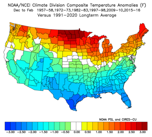
Definition: December, January, February period with sea surface temperature Anomaly 1.5 degrees C or greater
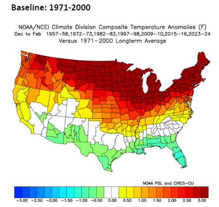
1957-58, 1972-73, 1982-83, 1997-98, 2009-10, 2015-16, 2023-24
Compared to the last 30 year average it looks like this…

So the big difference was South and West was both warmer than typical strong Nino’s. That’s what made this year so potent. In the warming world we are seeing due to climate change it’s more notable that this is compared to the last 30 years because the previous decades were colder. So, if we look at 1971-2000 averages then it’s even more extreme how hot a strong El Nino can be for America.
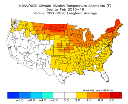
A year that closely matched was very recently in 2015-2016.


Besides the El Nino the other impact was the Pacific Decadal Oscillation and the Madden Julian Oscillation among others. The pressure and temperature fluctuations in different parts of the world influence where ridges and troughs set up.
Because of where high pressure was located it pushed the Arctic and Polar jet stream well north. The sub-tropical jet stream hit into the United States across the Pacific Ocean and flooded the country with mild air while the northern jet streams could not bring much cold south. With much of Canada also featuring much above average temperatures there was no big source for nippy winter temps.
Conclusion
The warm winter of 2023-2024, driven in part by El Niño, highlights the complex interplay between natural climate cycles and human-induced climate change. While the immediate effects of this warm winter are evident, its long-term implications for ecosystems, water resources, and economic sectors remain to be fully understood.
Want more information on this?
