
ENSO loads the dice. It does not roll them.
For snow and ice professionals, that may be the most important way to think about NOAA’s latest El Niño update.
NOAA’s Climate Prediction Center issued an El Niño Advisory September 10, reporting that El Niño is strengthening and putting the odds of a very strong event during the Northern Hemisphere fall and winter of 2026–27 at greater than 90%. For October–December 2026, NOAA gives a 75% chance that the event reaches historic strength, defined as a three-month Relative Oceanic Niño Index (RONI) value of +4.5°F/2.5°C or greater, exceeding the strength of prior events in the record dating to 1950.
Those are big numbers. But they are not a 90% chance or 75% chance of a particular amount of snow in Minneapolis, Buffalo, Denver, Chicago or anywhere else.
That distinction matters.
For contractors, dealers, manufacturers, suppliers and municipal operations teams, the September update is best treated as a seasonal risk signal: something that changes the background probabilities and deserves a place in planning conversations, but not something that replaces regional weather forecasts.
El Niño is strengthening
The September discussion shows a tropical Pacific that is becoming increasingly warm and increasingly coupled to the atmosphere.
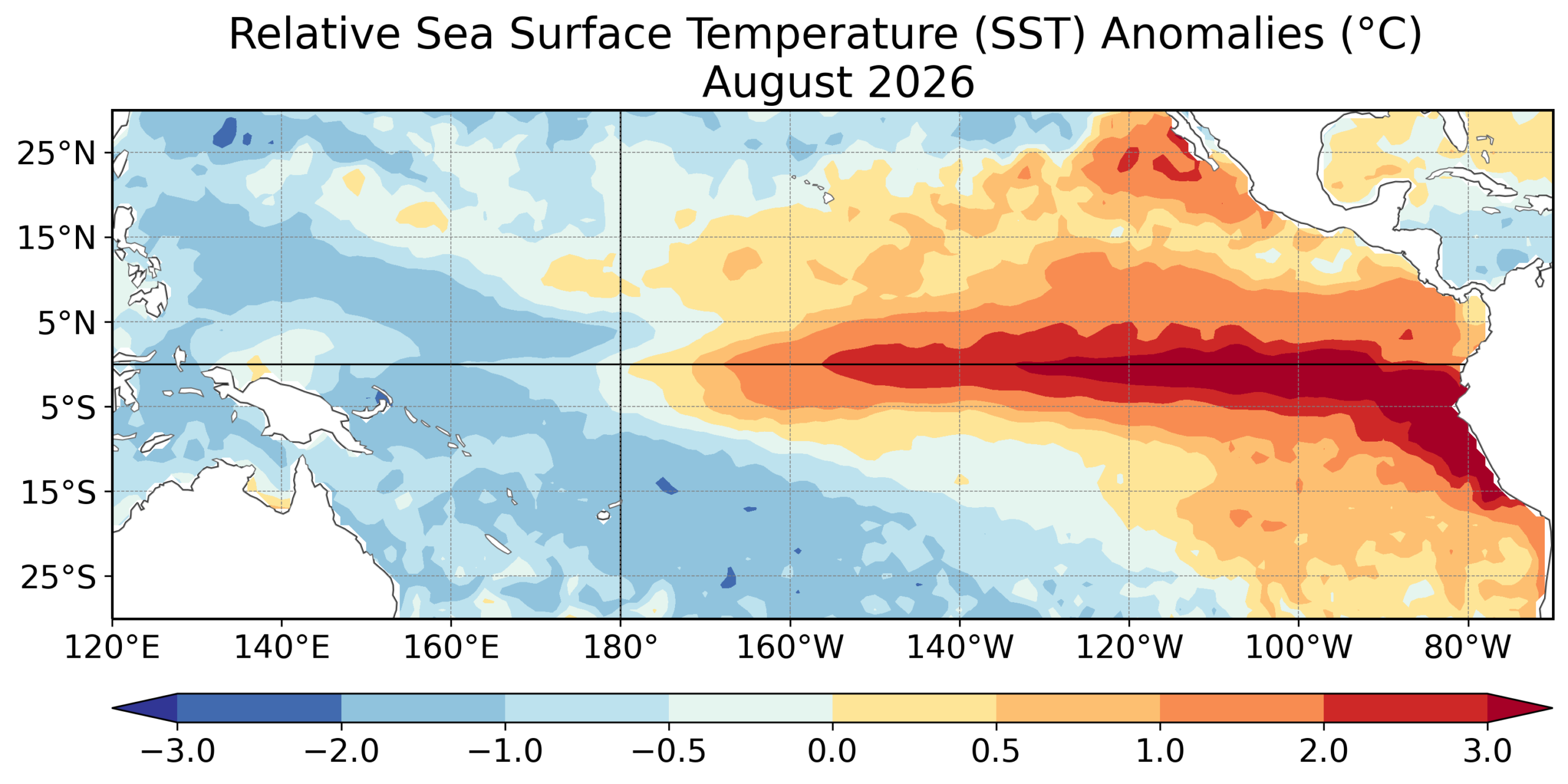
In August, the Niño-3.4 index reached +3.24°F/1.8°C. Other eastern Niño regions were warmer still, while NOAA reported widespread subsurface temperature anomalies exceeding +10°F/10°C at depth. Sea-surface-temperature anomalies exceeded +5.4°F/3.0°C in the eastern equatorial Pacific. NOAA also reported atmospheric changes consistent with a strengthening El Niño, including enhanced rainfall from the central to eastern Pacific and suppressed activity near Indonesia.
NOAA expects El Niño to continue strengthening through the end of 2026, followed by weakening during 2027.
For the snow and ice industry, however, the important question is not simply, How strong is El Niño?
It is:
How does a stronger El Niño change the odds of the temperature and precipitation patterns that actually drive winter operations in my market?
ENSO is a weather engine, not a local forecast
ENSO (the El Niño/Southern Oscillation) is a large-scale pattern centered in the tropical Pacific. When the ocean warms and the atmosphere responds, the resulting changes can influence the position and strength of the jet stream, storm tracks and large-scale circulation across North America.
Think of the tropical Pacific as one of several major weather engines.
When that engine shifts, it can load the dice for certain broad patterns. But the individual rolls—when storms develop, where they track, how much cold air is available, whether precipitation falls as snow or rain, and how long a cold pattern lasts—are still determined by many other pieces of the atmosphere.
That is why a strong El Niño can produce a recognizable national pattern without producing the same winter in every city.
And it is why an ENSO forecast should never be converted directly into a snowfall forecast.
Three NOAA charts worth watching
1. August sea-surface-temperature map — The Pacific signal is getting stronger.
The August observations show substantial warmth across the equatorial Pacific, with the strongest anomalies in the eastern portion of the basin.
2. Official RONI outlook — The event is expected to peak at exceptional strength.
NOAA’s September RONI outlook places the central forecast for October–December at +4.8°F/2.67°C, with a 75th-percentile value of +5.22°F/2.90°C. RONI is a measure of the tropical Pacific temperature anomaly used to characterize ENSO strength; it is not a direct measure of U.S. snowfall or temperature.
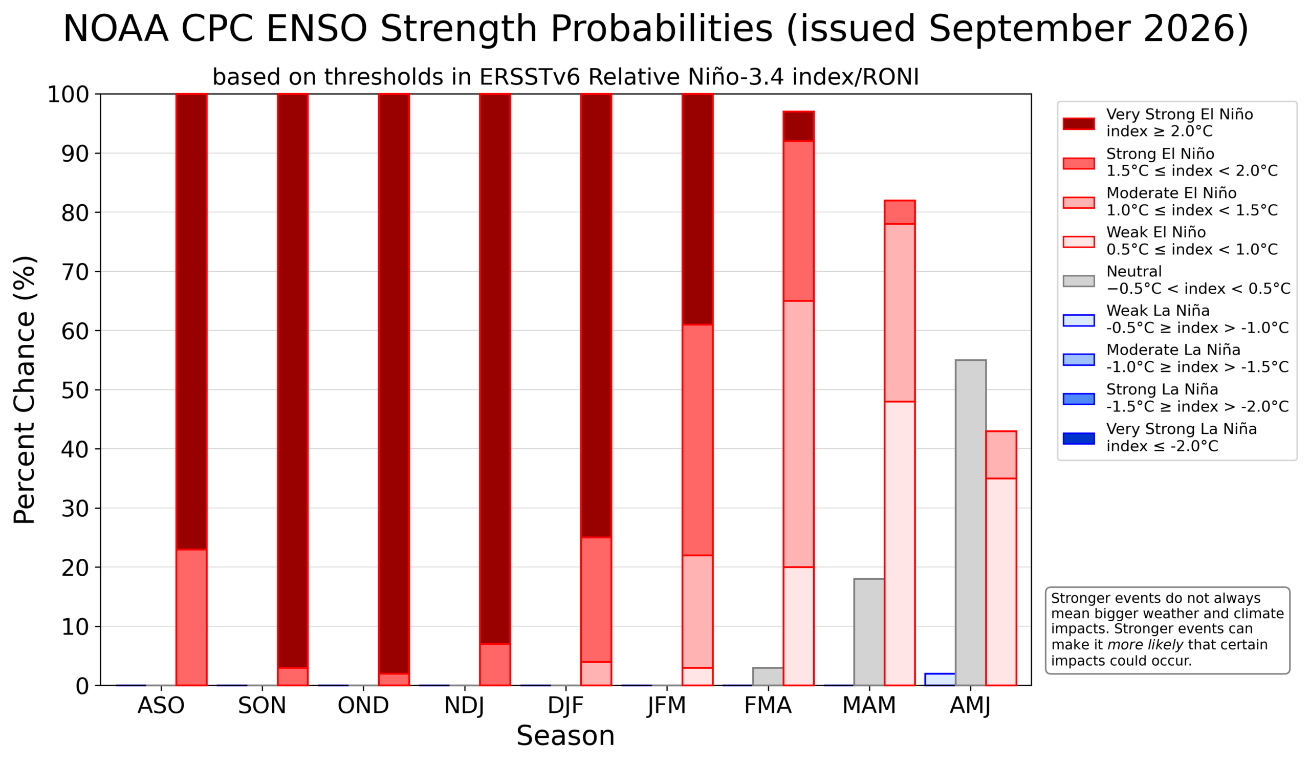
3. ENSO phase/strength probabilities — Confidence in El Niño is extremely high.
NOAA’s September probabilities put El Niño at 100% for several overlapping three-month periods from late summer through winter, with the event’s strength distributed among weak, moderate, strong and very strong categories. These probabilities describe the state of ENSO, not the probability of a particular local winter outcome.
What that really means…
A 75% probability of historic-strength El Niño means there is a 75% probability of the ENSO index reaching NOAA’s defined threshold during October–December. It does not mean there is a 75% probability of above-normal snowfall.
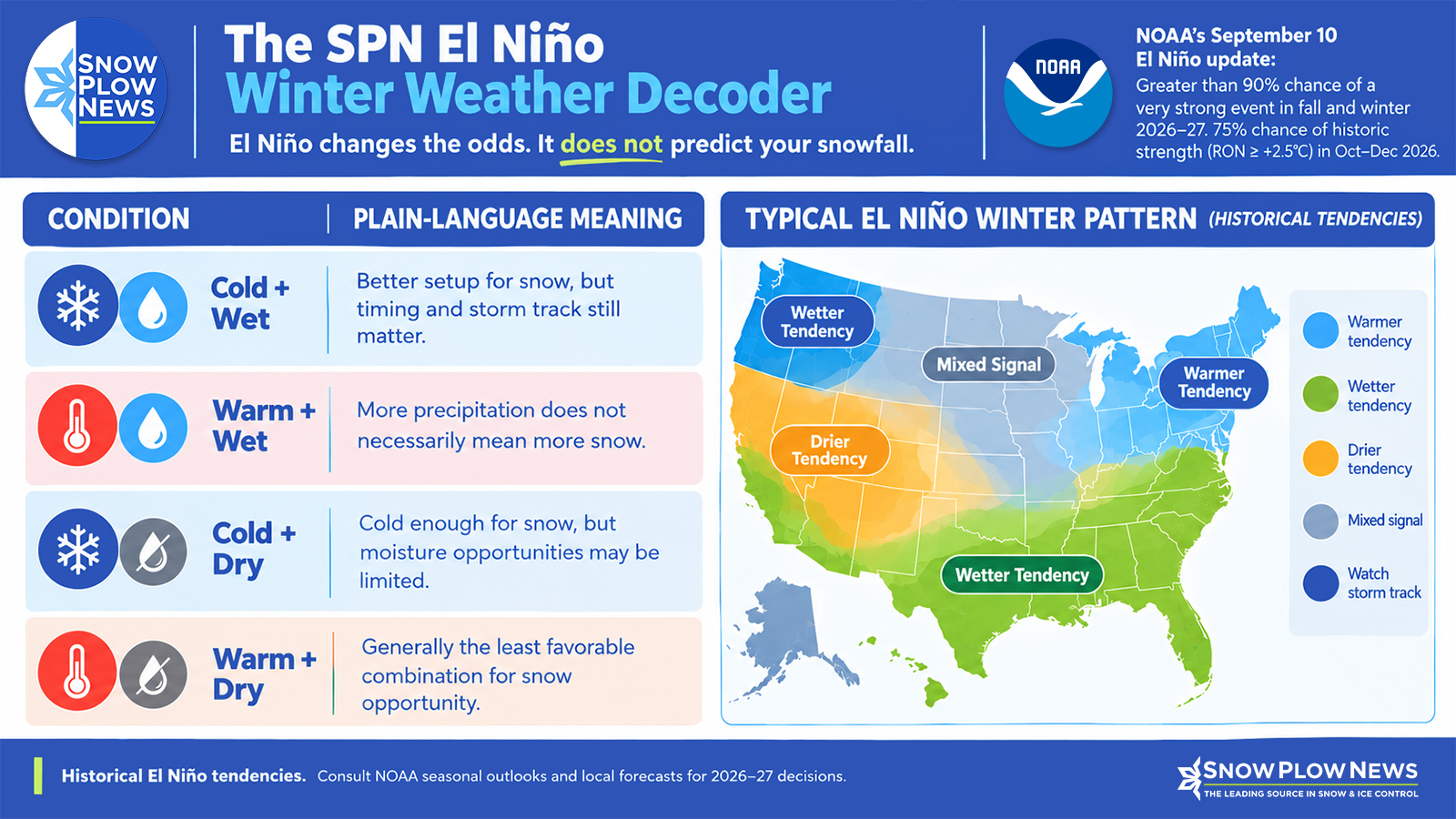
What El Niño usually does to the North American winter pattern
Historically, El Niño winters tend to favor a stronger southern storm track and can favor milder conditions across portions of the northern tier.
Those are historical tendencies—not promises for winter 2026–27.
The distinction becomes especially important for snow and ice operations because temperature and precipitation have to work together.
A storm track may produce substantial precipitation, but if temperatures are above freezing, the result can be rain rather than snow. Conversely, cold air without sufficient moisture may produce little operational snow or ice.
NOAA’s seasonal outlook discussions use ENSO as one of several inputs, along with dynamical models, statistical tools and analogs. The current CPC outlook, for example, incorporates the strong El Niño signal while also accounting for the event’s eastern-Pacific orientation and its evolution from the preceding La Niña winter.
So the useful question for a snow professional isn’t simply, “Is El Niño good or bad for snow?”
It is:
Does my region have the temperature and precipitation setup needed to turn the large-scale signal into snow and ice opportunities?
Apply the cold-and-moisture test
A simple operational framework can help translate seasonal climate information without overinterpreting it.
| Temperature pattern | Precipitation pattern | Snow/ice implication |
| Cold | Wet | More supportive of snow and ice opportunities |
| Warm | Wet | More potential for rain or mixed precipitation than snow |
| Cold | Dry | Cold may persist without producing many events |
| Warm | Dry | Generally least supportive of snow and ice demand |
This is not a forecasting model. It is a way to think about the problem.
For example, a seasonal outlook that tilts a region toward above-normal precipitation does not automatically mean a busy snow season. If temperatures are also favored to run above normal, some of that precipitation may arrive as rain.
Likewise, a colder-than-normal signal does not guarantee a strong season for contractors if precipitation is limited.
The operational sweet spot is often cold enough plus wet enough, and that combination varies substantially by geography.
That is why NOAA directs users toward its official seasonal temperature and precipitation outlooks for probabilities of regional anomalies rather than using ENSO strength as a substitute for those products. NOAA explicitly notes that stronger ENSO events increase the chances of impacts consistent with El Niño but do not guarantee them.
What this means for snow and ice businesses
The September ENSO update is useful because it gives the industry an early indication that the background climate signal is unlikely to disappear before winter.
That can support awareness and preparation, but it should not trigger a wholesale change in inventory or capital plans by itself.
Staffing
An El Niño signal can become one input into staffing discussions, especially for operations that cover large territories with different climate regimes.
But staffing decisions should continue to be based on local climatology, customer commitments, recent weather trends and shorter-range forecasts—not ENSO alone.
Salt and deicing inventory
The same principle applies to salt, treated products and other consumables.
A strong El Niño is not a reason by itself to dramatically increase or decrease inventory. Instead, operators can use the developing seasonal signal as a reason to revisit assumptions:
- What happens if the season is warmer but still wet?
- What happens if the regional pattern turns colder than the broad El Niño tendency?
- How much flexibility exists for replenishment?
- Which products perform best under different temperature regimes?
That is more resilient than betting the business on one seasonal headline.
Equipment readiness
The September signal is an excellent reminder to make sure equipment is ready before the first meaningful event—not because NOAA has predicted a particular storm, but because winter planning windows are narrowing.
Spreaders, plows, liquid systems, loaders, trucks, communication systems and backup equipment all benefit from being ready before confidence becomes high enough for individual storms.
Contract mix
For contractors, El Niño can also be a useful prompt to examine contract exposure.
A company with a large concentration of snow-only work may have different risk than one with diversified grounds, sweeping, landscape or facility services. Seasonal climate signals can inform that risk discussion without becoming a justification for assuming a particular snowfall total.
Customer expectations
Perhaps the most important operational use is communication.
Customers may hear “historic El Niño” and assume that means either a huge snow season or a snowless winter.
Neither conclusion is justified.
The better message is:
NOAA has high confidence that a very strong El Niño will develop, and that changes the background probabilities for certain winter patterns. It does not determine how much snow any individual location will receive.
That is a much more defensible way to talk about seasonal risk.
The September baseline for Winter Weather Watch
The September 10 update gives snow and ice professionals a strong starting point for the 2026–27 season.
NOAA’s message is unusually confident about the ENSO state: El Niño is strengthening, there is greater than a 90% chance of a very strong event during Northern Hemisphere fall and winter 2026–27, and NOAA assigns a 75% chance of a historic-strength event during October–December.
But confidence in ENSO should not be confused with confidence in local snowfall.
That is the central lesson for the industry:
ENSO loads the dice; it does not roll them.
For operational decisions, the next step is to watch the dice as the season approaches.
NOAA’s monthly ENSO Diagnostic Discussion will provide the next major update, while weekly monitoring will track how the ocean-atmosphere system evolves. NOAA’s official seasonal outlooks provide the more directly useful information for regional probabilities of temperature and precipitation. The September outlook suite includes forecasts extending through the 2026–27 winter and into spring 2027.
For Snow & Ice Pros, this September update is therefore best viewed as the baseline for a recurring Winter Weather Watch: establish the large-scale signal now, keep uncertainty visible, and then progressively narrow the operational picture as regional temperature, precipitation and shorter-range storm forecasts become more informative.
The goal isn’t to predict the winter in September.
The goal is to be better prepared for the range of winters that remain possible.
Sources:
- Primary ENSO Diagnostic Discussion landing page: https://www.cpc.ncep.noaa.gov/products/analysis_monitoring/enso_advisory/index.shtml
- Official RONI outlook: https://www.cpc.ncep.noaa.gov/products/analysis_monitoring/enso/roni/outlook/
- Official ENSO phase probabilities: https://www.cpc.ncep.noaa.gov/products/analysis_monitoring/enso/roni/probabilities/
- Official ENSO strength probabilities: https://www.cpc.ncep.noaa.gov/products/analysis_monitoring/enso/roni/strengths/
- NOAA seasonal outlooks: https://www.cpc.ncep.noaa.gov/products/predictions/long_range/
- North American winter features: https://www.cpc.ncep.noaa.gov/products/analysis_monitoring/ensocycle/nawinter.shtml
- ENSO current conditions and expert discussions: https://www.cpc.ncep.noaa.gov/products/precip/CWlink/MJO/enso.shtml
Want more information on this?